
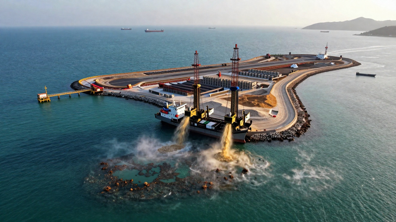
Just before sunrise in the South China Sea, the water can seem deserted: a narrow grey band at the horizon, a handful of lights that might belong to fishing boats, and the subdued mechanical drone familiar to those who live beside the coast. Then daylight arrives, the mist clears, and the apparent open ocean exposes something very different: a runway, cranes, concrete and radar domes.
These “islands” do not appear on older maps. People who spent their childhoods sailing past the reefs recall only coral and waves. Satellite photographs now reveal hexagonal jetties, hangars and immaculate lengths of tarmac laid directly across what were once sandbanks.
The world is focused on Gaza, Ukraine, elections and AI. Meanwhile, dredgers here continue working 24/7.
Hardly anyone is following it as it happens.
How China is quietly drawing new borders in the sea
Viewed from above, China’s new artificial islands appear almost orderly: crisp right angles, white runways and defensive sea walls surrounding shallow turquoise lagoons. At water level, however, they resemble enormous floating strongholds that have emerged without warning.
Projects initially presented as “reef reclamation” have become a gradual remaking of the map along one of the planet’s busiest trading corridors. Beijing describes them as development and defensive infrastructure. Its neighbours see physical evidence that the sea they have always known is closing in around them, dredger load by dredger load.
Official maps of the South China Sea now contain airstrips and outposts that did not exist fifteen years ago. Beneath those precise lines lies a stark question:
Who actually owns the blue spaces between them?
Fiery Cross Reef offers one example. Once little more than a speck familiar mainly to fishermen and naval chartmakers, it began changing around 2014. Satellite images showed plumes of murky water spreading outward as Chinese dredgers drew sand from the seabed and sprayed it across the coral. The reef rapidly grew in size. A few years later, it had a 3,000-metre runway and a deep-water port.
The same approach was used elsewhere. Subi Reef, Mischief Reef and several other features in the Spratlys expanded into fully developed islands, equipped with combat-aircraft shelters and extensive anti-ship missile sites. Vietnam and the Philippines rushed to enlarge their own positions, but they were beginning with rusty jetties and tin-roofed huts.
Before much of the world had properly registered what was happening, the essential reality had already been built into the sea.
Concrete is not easily undone.
Strategists use a detached phrase for this: “creating facts on the water.” Construct first; negotiate afterwards. China relies strongly on its expansive “nine-dash line” claim, a U-shaped boundary extending deep into waters also claimed by Vietnam, Malaysia, Brunei, the Philippines and Taiwan. Within that line, Beijing behaves not so much as a claimant as an owner.
Every additional island can support radar systems with ranges of hundreds of kilometres, anti-air batteries and harbours for coast guard and militia ships. Together, those installations turn isolated reefs into an effectively unsinkable network running from Hainan Island to the outer edge of Indonesia’s waters.
Let’s be honest: few people redraw their mental map of the world every time another load of concrete is poured into the sea.
China is quietly relying on that delay.
The playbook behind the new “island” frontier
There is a broadly familiar sequence in the creation of one of these islands. A small group of ships first gathers around a partly submerged reef or shoal. Dredgers drop their pipes, vacuum sand from the seabed and fire it over the coral like a high-pressure hose. Bulldozers level the rising ground, while sea walls are poured, formed and strengthened.
Satellite imagery captures the transformation stage by stage: a reef, then a blur, then a freshly created shoreline. Once the land sits high enough, temporary structures emerge, followed by permanent buildings marked by vivid blue roofs.
Runways, radar equipment and hardened shelters are added only afterwards.
By then, the island appears…established.
The projects’ human tension is often overlooked. Filipino fishermen using small wooden bancas describe being forced from traditional fishing grounds by white-hulled Chinese coast guard vessels, with water cannons powerful enough to break masts. Vietnamese crews describe ships that shadow them without quite making contact, yet never retreat either.
We have all experienced the moment when something assumed to be “just how things are” abruptly no longer feels like it belongs to us. At sea, that feeling becomes bound up with livelihoods, family debts and national pride.
On radio and television discussions in Manila and Hanoi, callers complain about “losing the sea”, while specialists debate maps produced in rooms far from the shoreline.
With every fresh mound of sand, the distance between those worlds widens.
In geopolitical terms, the strategy concerns pace as much as land. Actions proceed slowly enough to avoid daily outrage, but consistently enough to alter the balance year after year. Western navies conduct “freedom of navigation” patrols, pass the new islands and issue firm statements. The vessels then depart. The islands remain.
One US analyst described the pattern like this:
China is fighting a “war of inches” in a world that’s tuned to notice only wars of miles.
For Beijing, every reef converted into an island is a future negotiating asset, another radar horizon and an added layer of deterrence. For others, it produces a growing awareness that the map is changing more quickly than politics can respond.
- Land where there was only water
- Concrete that outlasts news cycles
- A slow, quiet shift in who feels at home at sea
What this slow-motion land grab means for the rest of us
The South China Sea can easily be seen as a remote chessboard, yet developments there affect supermarket shelves and fuel bills. About a third of global shipping travels through these waters: tankers, container vessels and bulk carriers transporting the ordinary goods of modern life. Should those routes become more controlled or more dangerous to navigate, insurers increase premiums and shipping companies alter their routes.
Those costs do not remain offshore. They can appear in the price of a smartphone, the waiting time for a car component or the cost of heating a home in winter. A disputed reef that you could not identify on a map can quietly weigh on your monthly budget.
The islands also operate as forward warning stations, monitoring military aircraft and submarines far beyond their coastlines.
Control of the sea is quietly becoming control of the story.
| Key point | Detail | Value for the reader |
|---|---|---|
| New islands as military hubs | Runways, missile sites and ports built onto former reefs | Helps you understand how power is physically extending across the sea |
| Everyday impacts on trade | Busier chokepoints bring greater shipping risk and costs | Links distant disputes to prices and delays experienced at home |
| Slow, unnoticed change | “Facts on the water” become fixed before politics or public debate can catch up | Draws attention to changes that rarely reach front-page headlines |
FAQ:
Question 1 Are these new Chinese islands legal under international law?
A 2016 international tribunal found no legal basis for China’s sweeping historic claims in the South China Sea, and concluded that some features were low-tide elevations rather than islands. Beijing rejected the decision and continued, wagering that concrete and time count for more than court papers.Question 2 Why are other countries so concerned about sand and concrete?
Once a reef is turned into a fortified island, it can accommodate radar, missiles and runways that alter the military balance. This affects how secure neighbouring states feel in their own waters and how freely commercial vessels can travel through disputed areas.Question 3 Is this only happening in the South China Sea?
The most conspicuous island-building is taking place there, but comparable “grey zone” methods are visible elsewhere: ports with dual-use facilities in the Indian Ocean, enlarged bases on natural islands and a substantial coast guard presence in disputed areas near Japan and Taiwan.Question 4 Could these islands trigger a war?
The larger danger is not one dramatic flashpoint, but an accident: a collision, an incorrectly interpreted radar trace, or a pilot or captain making a split-second decision. Each new installation reduces the space in which rival forces operate close to one another with very little trust.Question 5 What can ordinary people actually do about any of this?
You cannot relocate an island, but you can decide which stories to follow and circulate. Paying attention to gradual structural changes-such as who is constructing what at sea-encourages media organisations and politicians to regard them as more than background noise.



Comments
No comments yet. Be the first to comment!
Leave a Comment