
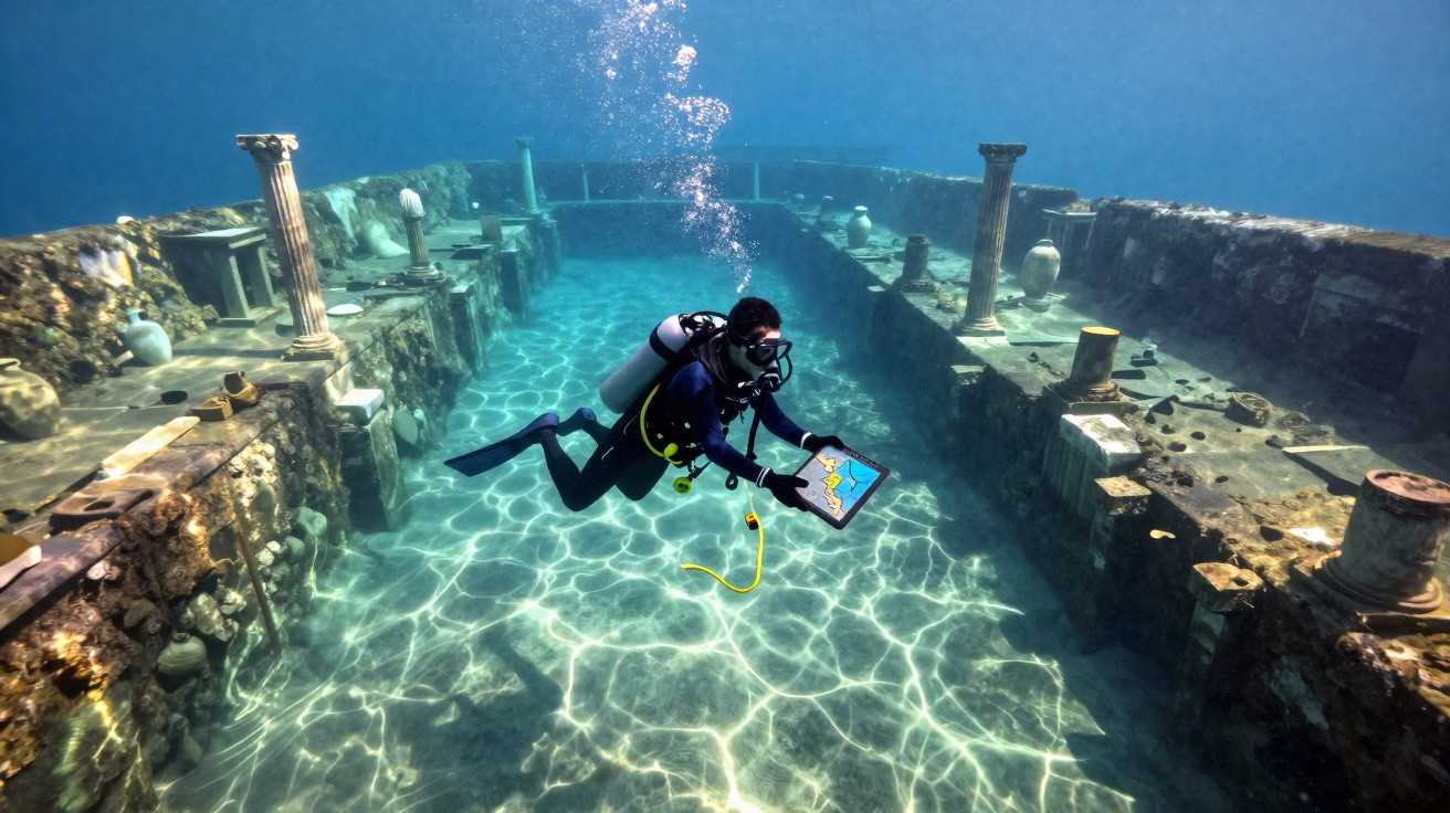
Along certain Mediterranean beaches, a careful look at the water can be enough to suggest another shoreline. A column breaking the waves, blocks set out in rows a few metres from the sand, an anchor brought up by a fisherman: for decades, such clues were regarded as isolated remains of modest harbours. Then divers began descending, methodically, equipped with sonar and millimetre-accurate surveys. What they uncovered was not merely a stray jetty beneath the sea, but basins, warehouses, quays and, in some cases, whole districts. The ancient landscape did not end where the water begins. It was only just beginning.
Beneath the waves: a geography no one could see
From land, an ancient harbour often appears as an unfinished outline: a handful of ruins, a broken mole, a salt-worn row of stones. Archaeologists had sound reasons to rely on these visible traces, as they were accessible and already revealed much about Roman, Greek and Egyptian trade. Yet the sea keeps its secrets with formidable patience. As teams investigate the seabed, they are finding that harbour installations stretched much farther out, at times across several hectares that are now submerged.
The example of Thônis-Héracléion in Egypt made a lasting impression. This port city, swallowed by the sea off Aboukir, has yielded temples, monumental statues, shipwrecks and mooring areas on a scale far beyond the picture of a mere coastal trading post. Researchers have recorded dozens of ancient wrecks there, some associated with shipments of grain, wine or goods arriving from the eastern Mediterranean. Beneath the murky surface, the harbour emerges as an immense crossroads: a kind of maritime station ahead of its time.
The discovery overturns a persistent assumption: ancient towns did not simply turn their backs on the sea; they existed alongside it. Their quays could be used for unloading, storage, ship repairs, tax control and religious ceremonies. When sea level rises, an earthquake causes a coastline to subside, or sediment advances, the map becomes blurred. The sea has not erased the past; it has shifted it into a different light.
Why archaeologists are redrawing ancient coastlines today
To establish a harbour's true extent, researchers no longer limit themselves to dives around its best-known ruins. They combine sonar images, GPS surveys, sediment cores and ancient texts, then reconstruct changes in the shoreline century by century. It is painstaking work, almost domestic in its approach: each object is put back in place, measured, compared and reconsidered. An irregularity on a screen may prove to be a buried quay. A pile of stones can become a warehouse after several field seasons.
At Caesarea, on Israel's coast, the remains of the harbour built under Herod demonstrate just how ambitious ancient engineering could be. Artificial breakwaters, made from Roman concrete able to set underwater, sheltered a large maritime basin. Underwater excavations have identified areas that erosion and shifting coastlines had made almost impossible to read from land. Let us be honest: hardly anyone does this every day, including history enthusiasts. Even so, seeing a sonar image quickly changes how one imagines antiquity.
A common mistake is to assume that visible ruins represent an entire site. More often, they are simply its most resilient part: the section that endured storms, the reuse of stone and modern construction. Archaeologists must also resist another temptation, namely interpreting a geometric shape as a building too quickly.
“Underwater, every line can be a discovery, but it can also be a question that needs time to mature.”
- Sonar detects relief hidden beneath sediment.
- Photogrammetry produces accurate 3D models of the seabed.
- Soil cores reveal changes in sea level and deposited material.
Larger ancient harbours, a more eventful ancient history
This research does more than place a few extra points on a map. It reveals the intensity of a world in which ships connected distant cities and carried amphorae, metals, spices, enslaved people, ideas and beliefs. At Baiae, near Naples, submerged Roman structures trace a coastline reshaped by bradyseism, the slow ground movement linked to volcanic activity. Where visitors now see calm water, villas and harbour facilities lie several metres below the surface.
The same phenomenon also affects Alexandria, Portus near Rome, the shores of the Aegean Sea and parts of the French coast. Each location tells a different story of adaptation: one town was inundated, another saw its harbour silt up, while a third changed purpose over the centuries. Ancient harbours were living organisms, able to expand, relocate and sometimes vanish while leaving little evidence on land. That reality gives underwater discoveries an almost intimate quality: they bring into view places that even their former inhabitants might struggle to recognise.
There is also a vulnerability that archaeologists understand only too well. Stronger storms, warming waters, coastal urbanisation and looting endanger remains that have not always been examined. Sharing these discoveries is not an invitation for everyone to search for an amphora with mask and fins; it is a way of learning to view a familiar stretch of coast differently. Behind a modern sea wall, beneath a marina or at the foot of a hotel, the silent outline of an old commercial world may still survive.
| Key point | Detail | Added value for the reader |
|---|---|---|
| Underestimated harbours | Quays and basins often continue beneath present-day waters. | Understand why land-based ruins reveal only part of a site. |
| Crucial tools | Sonar, photogrammetry and core sampling expose submerged structures. | See how underwater archaeology is reshaping ancient maps. |
| Fragile heritage | Erosion, pollution and looting put the remains at risk. | Appreciate the urgency of documenting these unseen landscapes. |




Comments
No comments yet. Be the first to comment!
Leave a Comment